
Is there a way to design and implement a customised green infrastructure for new settlement expansions? This article shows how a multifunctional and interdisciplinary planning approach can be used to develop a new settlement area in the city of St.Pölten called “Eisberg” despite climate change.
The St.Pölten City Region
The ninth largest city in Austria is located in the Traisen valley and has been the capital of the largest province of Lower Austria for 35 years, with a population of about 56,000. In this medium-sized city region about 60 km west of Vienna, more than 85,000 people live in the direct catchment area (18 surrounding municipalities). Together with the neighbouring small town region of Krems in the north, there are over 130,000 inhabitants. The urban area covers 108.44 km², about a quarter of Vienna, and is thus significantly larger than that of the second to fourth largest cities (Graz, Linz, Salzburg, Innsbruck) and has a rural appearance in large parts. As the administrative centre of the province, the number of employed persons is almost as large as the number of inhabitants, at over 51,000.
Green space planning for St.Pölten
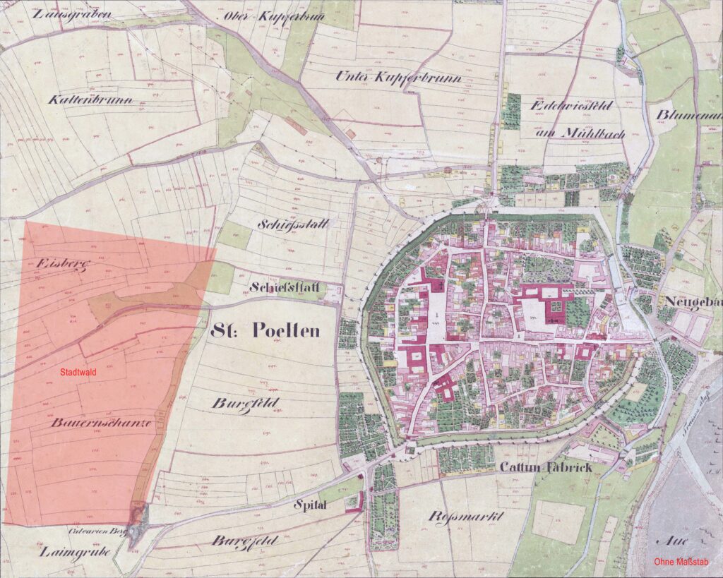
The rapid urban development at the end of the 19th century meant that a regulation plan resulting from a competition became legally binding as early as 1887. Initially, there was no green space planning of its own, but with the increasing importance of the city centre, this also became relevant. In 1928, the city’s planning department pointed out the necessity of purposefully securing green spaces. At that time, the specially developed green zone plan was justified by the city dwellers’ needs for recreation and nutrition. It was not until 53 years later that the city planning department took this concept further, followed in 1990 by its own digital landscape and green space concept developed by the Vienna University of Technology. Finally, in 2010, on the basis of the Lower Austrian Spatial Planning Act, it was possible to create a “landscape concept” from scratch, with a system of “green veins” specific to St.Pölten (Büro land.schafft©). After a decision was made by the municipal council, all points were incorporated into the Integrated Urban Development Concept (ISEK 2016 – Stadtplanung & Emrich Consulting ZT GmbH).
The Iceberg
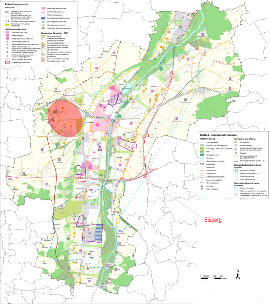
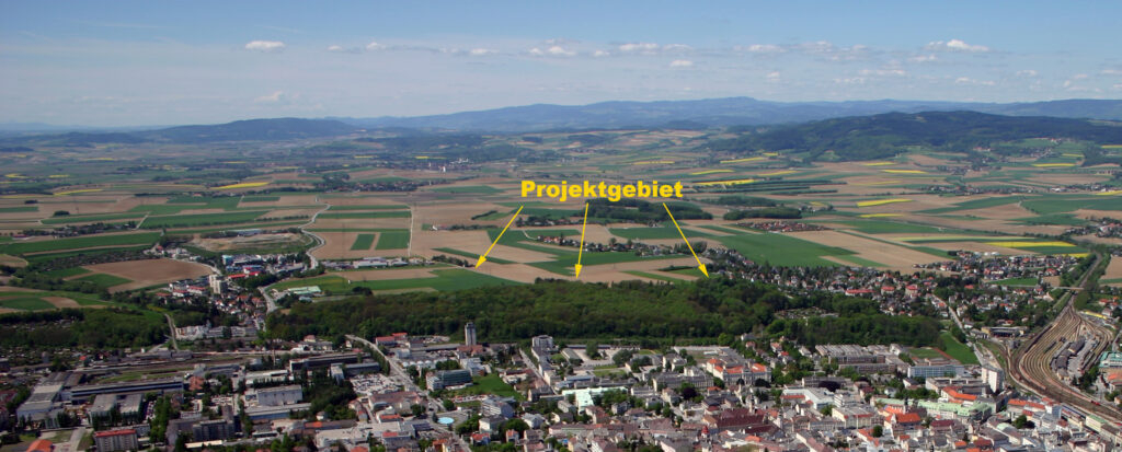
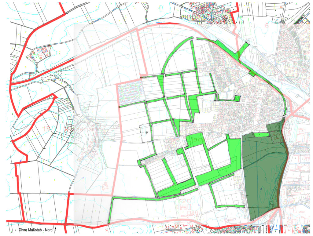
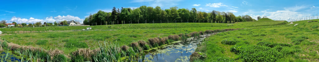
The approx. 85 ha urban development area directly to the west of the St. Pölten city forest and the approx. 110 ha urban expansion area Eisberg West adjoining it to the north have been worked on integratively in several steps over the last ten years, from the largescale to the small-scale. After the landscape concept in 2010, a separate green space development concept followed in 2012 as a detailed basis for the urban development concept. In 2016, selected aspects of the detailed design of the open and green spaces could be conceptually worked on as part of a course at the University of Natural Resources and Applied Life Sciences (“embedding green infrastructure @ stadt.wald.eis.berg.west” Institute for Engineering Biology and Landscape Construction). In 2017, an interdisciplinary planning workshop brought development solutions for the entire area on an urban planning level, starting from the green space concept as a bracket. In order to “settle” the iceberg, to enable development and to make the open spaces usable, the landscape must be redesigned so that meadow areas, forest and windbreak belts hold back wind and water. Surface runoff needs to be channelled through swale systems, stored in large detention basins and slowly released. In 2019, the first section was developed, and construction has been underway since then. For this purpose, it was necessary to continue with the corresponding green space planning and to implement it structurally.
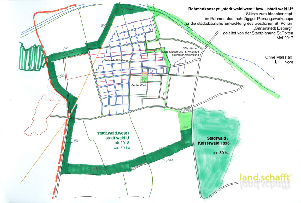
Green infrastructure for the Eisberg
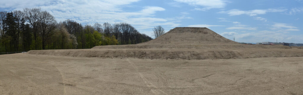
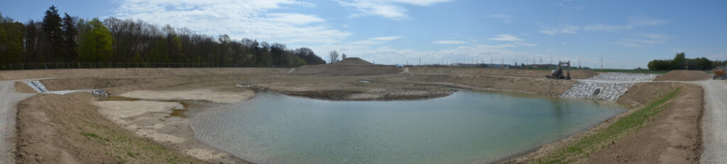
A green (and at the same time blue) infrastructure is a prerequisite for any settlement development on the Eisberg and will be brought together for this purpose in a large recreational area that can be used in a variety of ways. In the “City Forest West”, as a linear extension of the Kaiserwald, a forest belt at least 100 m wide and altogether approx. 1.5 km long will be drawn to the west, accompanied by open areas of meadows, dry-falling channels, ground and windbreak hedges, rows of trees and avenues as well as large retention basins. In the long term, the entire Eisberg is to be encompassed in a U-shape as far north as the railway line. This mega-project of landscape redesign started in October 2020 with the construction of the first retention basin along Kunrathstraße, which will become part of the first section of Stadtwald West as a multi-functional green space, on a total of approx. 10 ha. In order to minimise transport, most of the large excavated material for the construction of the blue infrastructure had to be placed in the future recreation area and modelled for a variety of uses. The planned green infrastructure, as a multifunctional continuation of the historic urban forest, will also integrate the blue infrastructure to create a coherent, contemporary urban landscape adapted to climate change.
Practical and symbolic aspects of the climate change adaptation concept
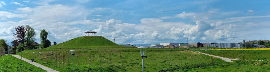
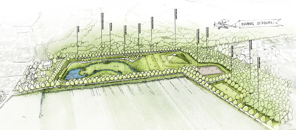
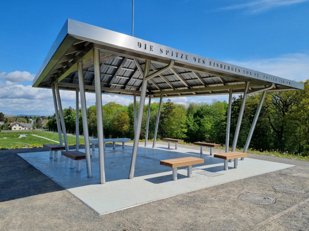
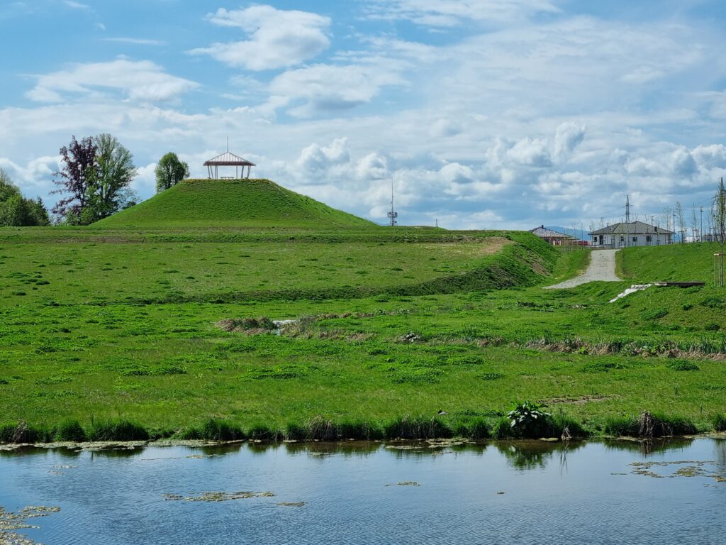
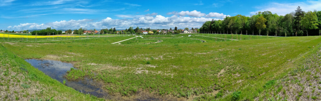
This sustainable urban development against climate change follows the design idea of the “melting iceberg”. With the help of the excavation for the basin, an actual, small iceberg was piled up, topped by a pavilion that rises 17.5 m above the Eisberg tongue basin, into which the iceberg symbolically melts over iceberg floes, terraced down into the iceberg floodplain and the ice pond. Right next to it, the Eisberg Forum forms the imprint of an already melted iceberg – a bowl-shaped, wind-protected hollow form with a central small playing field area (26 x 44 m), enclosed amphitheatre-like by a flat meadow slope for spectators.
Coming from the Waldstraße in the north, the Eisberg-Allee, which protects the area to the west, flows into it. It is accompanied by a catchment and a ground protection hedge, so that a protected motor park can be created towards the tongue basin, and at the foot of the iceberg, a small outdoor climbing centre with bouldering rocks at the forum. The Eisberg promenade branches off in an L-shape to the west, closing off the Eisberg forest and its upstream urban forest fringe to the north towards the future settlement area, accompanied by the “Stadtwald wadi”, an intermittent drainage ditch that flows into the tongue basin, where it borders the tongue-shaped Eisberg floodplain in two parts. With the help of mass balancing terrain modelling and planting diversified by area, a highly structured micro-landscape was created that encourages a variety of uses and offers many subspaces.
The appearance changes not only seasonally and diurnally, but also with the temporary filling of the water basin and the wadi, depending on the weather. The new recreation area offers kilometres of walking and running paths, trails on the Eisberg, “small” winter sports on the differently inclined slopes, team sports in the arena of the Eisberg Forum, sheltered hollows for sunbathing, relaxing or watching, freely usable lawns on the Eisberg floes, a playing field in the Stadtwald fringe and deliberately kept open zones that allow for as yet unknown, future recreational sports and ideas. The “summit” of the iceberg is formed by a (steel) pavilion whose roof continues the mountain shape and ends in a lightning rod peak that reaches exactly 310.0 metres. 3100 is the postcode of St.Pölten. It will be a central, high-level viewing and meeting point in the new Stadtwald West. A wind rose with inscription in the ground indicates the proximity/distance to the North/South Pole.
Preliminary summary
Urban development always requires correspondingly long-term, integrative master planning that is as interdisciplinary as possible in order to be able to sustainably (further) develop existing and new urban areas – especially to implement climate change adaptation strategies. At the Eisberg in St. Pölten, this adaptation could actually be implemented step by step with the help of a practical and symbolic design concept. In 2022, the first construction phase of the transformation of this landscape with new green and blue infrastructure for all city residents was opened. The “maturing process” of these new green spaces will still take many years, but an exemplary foundation stone has been laid for what urban development will look like in the future: integrative, inter-/multidisciplinary planning and implementation, for the development of a green and blue infrastructure before the actual construction.
The example shows how urban development can succeed from the perspective of green and blue infrastructure and build on it making St.Pölten’s urban life pulsate in the green veins.
(The image and photo rights are held by DI Dr. Alfred Benesch or the City of St. Pölten with kind permission for this article)